By Deanna Ramsay, originally posted on CIFOR’s Forests News
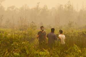
As flames swelled over a swath of peatland outside Palangka Raya in Central Kalimantan, Indonesia in October 2015, a group of scientists was downwind, measuring what was being released into the air.
And while that group worked amid smoldering land, satellites orbiting the Earth were recording detailed information at a distance – of the power of the fires and the carbon in the atmosphere.
The combination of those unique measurements and subsequent calculations has resulted in a pioneering study under the CGIAR Research Program on Forests, Trees and Agroforestry recently published in Scientific Reports – the first to determine the greenhouse gas emissions from the fires of 2015 in maritime Southeast Asia. The study’s authors determined that the carbon emissions released by the fires in September and October 2015 of 11.3 million tons per day were higher than those of the entire European Union, which daily released 8.9 million tons over the same period.
Starting from the bottom
The widespread landscape fires in parts of Kalimantan, Sumatra and Papua last year generated noxious smoke and haze affecting millions – and international attention – and the team on the ground was the very first to assess the emissions from actively burning peatland.
“There have been some isolated studies before where people artificially set fires in the lab to try to understand the chemical characteristics of peatland fire smoke in Indonesia. But no one had done this on natural fires, and especially not on the kind of extreme fires seen in 2015. We are the first people to do that,” said King’s College London professor Martin J. Wooster, one of the study’s lead authors.
The team used their measurements of ground-level smoke from burning peat to derive the emission factors, i.e. to understand how much carbon dioxide, carbon monoxide and methane is released for a particular amount of tropical peat burned.
Satellites provided data on the heat output being radiated by the fires, as well as information on the amount of carbon monoxide present in the surrounding atmosphere. From this, the total carbon emissions were determined by combining the satellite measurements and the Copernicus Atmosphere Monitoring Service (CAMS) modeling framework with the newly determined emission factors from fires around Palangka Raya – one of the hardest hit sites.
The researchers concluded that 884 million tons of carbon dioxide was released in the region last year – 97% originating from burning in Indonesia. The corresponding carbon emissions were 289 million tons, and associated carbon dioxide-equivalent emissions 1.2 billion tons.
Out of orbit
This groundbreaking work builds on decades of research following the massive fires in the region in 1997 (an El Niño year as was 2015) and new technological innovations like the CAMS framework, which can swiftly and accurately track fires and make assessments of their atmospheric impacts, and which offers its data freely.
“This sort of modeling has only been possible quite recently. When we saw the fires start in the region – knowing that it was an El Niño year – we were able to quickly start analyzing the situation, and we started contacting others who could contribute,” said study lead author Vincent Huijnen of the Royal Netherlands Meteorological Institute, who works on the CAMS framework.
Wooster concurred about the clarity of their calculations because of fresh technologies. “We found that this was the largest single fire event in terms of carbon emissions from Indonesia since 1997. We can much more confidently make our calculations because of the new satellite, modeling and field instrument technology that is now available compared to 20 years ago.”
Peat and El Niño
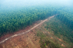
Comparing their findings to past exceptional ‘mega’ fire events helped to clarify landscape changes in the region and the altered emissions compositions, as approximately three-fourths of the fires in 2015 were on peatland.
“The conversion of peatland will remain a potential source of greenhouse gases, especially when fire is involved and when associated with prolonged drought in an El Niño year. It is so essential to protect peatland because it is a huge storer of carbon and Kalimantan has 50 percent of the world’s peat reserves,” said CIFOR scientist and study co-author Daniel Murdiyarso.
For David Gaveau, also a CIFOR scientist and study co-author, the fires in 2015 were different because they were primarily on drained, idle peatland.
El Niño, already degraded landscapes and peatland are important to the story of the 2015 fires, and the team’s emissions finding are striking, being the first to understand what is being released into the atmosphere from fires occurring on the region’s unique tropical peat.
“The last year has seen the largest single year atmospheric carbon dioxide increase since records began in the 1950s, and we calculated that the fires burning in Indonesia made up a significant component of the increase over what is ‘normal’ in non-El Niño years,” Wooster said.
Less hazy days
The impact of such work is, ironically, hard to quantify because of its wide implications. For Huijnen, such research contributes to larger debates about climate change.
“In measuring carbon dioxide in the atmosphere and attributing changes to different sources, you know how much is purely anthropogenic, or human, induced,” he said.
And with anthropogenic causes come anthropogenic effects that can impact millions. According to Murdiyarso, good policy is key – and providing numbers related to the 2015 fires can help. With the Indonesian government’s Peatland Restoration Agency established following the fires last year, there is movement to avert future fires.
“What is important is the applicability of a study like this in helping policy makers to use more accurate fire emission factors to design policy and act to prevent further fires,” he said.


