By Amy Cruz, originally published at ICRAF’s Agroforestry World Blog
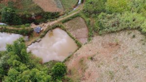
A monitoring system has the potential to help governments, research organizations and other groups detect changes in landscapes, such as deforestation and establishment of oil palm plantations.
Representatives from government agencies, research organizations and academe in the Philippines attended a forum on the near real-time monitoring of forest landscapes through the Terra-i Remote Sensing System. The event provided the participants a platform for discussing potential uses of the Terra-i system in the country.
Two sessions were jointly organized by the International Center for Tropical Agriculture (CIAT) and ICRAF The World Agroforestry Centre at the Diliman and Los Baños campuses of the University of the Philippines in October 2016. Louis Reymondin of CIAT explained the system, after which the participants discussed potential collaboration and uses in the country.
Robustly used in Latin America, the Terra-i system has recently gained interest in Southeast Asian countries such as Cambodia, Myanmar, the Philippines and Viet Nam as a near real-time monitoring system for habitat loss and landscape changes. The goal of the system is to detect as soon as possible changes in a landscape but not to exactly measure forest loss in hectares because of the limitations of the satellite sensor.
Terra-i leverages remote sensing and advanced machine-learning techniques to detect changes in a landscape. According to Reymondin, a team of researchers developed the system based on the premise that natural vegetation follows a predictable pattern of changes in greenness over time. These changes are based on site-specific characteristics and the climatic conditions of preceding days.
Read also: Terra-i, new data – new look for the website
The system predicts how green a pixel should be, given a unit of rainfall, and compares that specific pixel with satellite images. Any anomalies in the time series, which could be due to human activities, can be identified. The time series are produced in 250 m spatial resolution every 16 days to reduce the effects of cloud cover. Although it sounds complicated, Terra-i was designed to be implemented even with limited hardware and financial resources.
Such a system would help improve forest management, reduce emissions from deforestation and forest degradation and contribute to climate-change adaptation and mitigation. Some of the possible applications include detecting mining activities and new oil-palm plantations; assessing the effectiveness of protected areas; and developing potential deforestation scenarios from trends.
Other activities in the pipeline for Terra-i include:
- development of 30 m-resolution time series through combining pictures from different satellite systems;
- identification and characterization of degradation through combining images from satellites and unmanned aerial vehicles; and
- analyses of time series to tell ‘the story of the pixel’, for example, how are the changes spatially distributed and what happens after deforestation.
The team hope that later the system can be modified to monitor other types of ecosystems in the tropics. To achieve this, they will need local knowledge and data to calibrate pan-tropical data available from open-access satellite imagery.
This work is linked to the CGIAR Research Program on Forests, Trees and Agroforestry.