How can satellites help map and monitor critical peat landscapes?
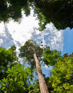
Dense, damp and often remote, tropical peatlands are notoriously difficult to map and monitor on the ground. So how about from space?
New methods using satellite data are finding increasing success in assessing the extent, distribution and even the volume of peatlands around the world, as well as monitoring threats to their sustainable management.
Some of the latest developments in this area were presented by the Center for International Forestry Research (CIFOR) and partners at a side event during the UNFCCC Bonn Climate Change Conference held in Germany from May 8-18.
The findings continue to challenge widely-held assumptions about where peat is located, how much of it is out there, and how it can be conserved and sustainably managed to contribute to efforts on global climate change mitigation and adaptation.
A NEW GENERATION OF DATA SOURCES
Frank Martin Seifert from the European Space Agency (ESA), a cohost of the side event in Bonn, shared the ongoing work of the European Copernicus satellite program, which currently operates a fleet of dedicated satellites for environment and civil security monitoring.
Five of the satellites, known as ‘Sentinels’, are already in orbit, imaging the surface of the Earth. The resulting data are available for free and open access by anyone, anywhere in the world.
But what about peat, which mainly lies below the Earth’s surface? Can a satellite detect that?
Watch: More peat in the tropics: Implications for climate change
“Most peat is not directly visible from space,” Seifert says. “But you can still derive a lot of the characteristics of peatlands, and any critical changes, from satellite images.”
Two of the Sentinels are particularly useful for mapping wetlands and peatlands, Seifert says. Sentinel-1 is a radar mission with cloud-penetrating, night-and-day imaging capability, while Sentinel-2, the high-resolution optical mission of the Copernicus program, can map the entire land surface of the Earth in a matter of days.
Together, these two satellites can detect extent, moisture and water levels of wetlands and peatlands, as well as threats to their environmental integrity, such as land conversion for agriculture and urban developments, logging in swamp forests, degradation and damage caused by fires.
As global efforts move toward conservation and restoration of peatlands, the data will also be useful for monitoring, reporting and verifying successes on the ground.
PUT INTO PRACTICE
As part of the Global Peatlands Initiative (GPI) launched at the 2016 Global Landscapes Forum in Marrakesh, ESA is developing and demonstrating methodologies for mapping and monitoring peatlands globally, and deriving best practices for use in the assessment of peatlands.
Demonstrations will take place in GPI’s three pilot areas — Indonesia, the Congo Basin and Peru — and further areas in the temperate and boreal zone. The findings will be useful for local, national and global efforts to conserve, manage and restore peatlands, as well as to tackle climate change.
In Indonesia, for example, satellite data can support ongoing efforts to better manage the country’s critical peatlands.
At the local level, peatlands in Indonesia support livelihoods and regulate essential ecosystem services. But draining, burning and conversion of peatlands for agriculture and other purposes is threatening the sustainability of the relationship between peat and people. Conversion and burning of peatlands are also a major source of greenhouse gas emissions, posing an increased threat of climate change.
Read also: Eyes on the livelihoods of peatland communities
The national government has responded by forming a Peatland Restoration Agency (BRG). But this body will need solid data to carry out its mandate and track its progress. So where will it find the information it needs?
“Satellite data has the advantage of providing a panoptic overview of an area, as well as indicators of threats,” Seifert says. “This makes it easier to control; easier to see what’s happening.”
The Sentinel-1 satellite was able to pick up areas burned by forest fires in Indonesia during the El Niño crisis of 2015. By combining this data with international peat inventories and national data on forest cover, researchers were able to calculate an estimate of the total greenhouse gas emissions from the fires.
The issues involved in managing Indonesia’s peatlands were further discussed in a new infobrief from CIFOR shared at the side event in Bonn.
GLOBAL DATA
Combined with ground data and modelling, satellites can help to ensure consistency and transparency of data, enabling international comparisons. ESA is also sensitive to the demands of countries to manage their own resources using their own data, and making their own assessments.
The Copernicus satellite data is available for free and open access, but capacity is needed to interpret and analyze it. Data analysis toolboxes can help build this capacity – for example, a new toolbox will be released later this year on wetland inventories and habitat mapping in Africa, to manage wetlands, assess threats and detect changes.
CIFOR and partners have also begun to develop data toolboxes, such as the Global Wetlands map, the CarboScen land-use scenario simulator and the Indonesia Peatland Network Toolbox, for managing peatlands in relation to climate change.
But even with these advanced tools at hand, further research will always be needed at the ground level to see how dynamics play out in the landscape.
“The challenge is how to bring these approaches together,” Seifert says.
By Catriona Croft-Cusworth, originally published at CIFOR’s Forests News.
For more information on this topic, please contact Daniel Murdiyarso at d.murdiyarso@cgiar.org.
This research forms part of the CGIAR Research Program on Forests, Trees and Agroforestry. This work is supported by CGIAR Fund Donors.